Title:
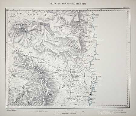
“Map of Western Palestins in 26 sheets from surveys conducted for the Committee of the Palestine Exploration Fund by Lieuts. C.R. Conder and H.H. Kitchener, R.E. during the years 1872-1877”
Map Maker:
Edward Stanford
This scarce set of 26 maps contains the first deta... (full text available to subscribers)
| Item Detail |
| |
| |
MapMaker: |
Edward Stanford
|
|
| |
| |
Subject: |
Holy Land |
|
| |
Period/Size: |
1880 / 27.5" x 23.3" (69.9 x 59.2 cm)
|
|
| |
Color: |
Colored
|
|
| |
Condition: |
(C) Maps are generally very clean with some chipping to first few maps - more so on map VII with loss into border. This fine set of scarce maps is deserving of some professional TLC. (condition help) |
|
| |
Source: |
The Palestine Exploration Fund |
|
| |
References: |
|
|
| |
|
|
| Sales Information |
| |
| |
Price: |
|
|
| |
| |
Offered by: |
Old World Auctions |
|
| |
Catalog: |
Auction No. 99 - Antique Maps, Charts, Atlases & Globes (304) |
|
| |
Lot/Item #: |
434 |
|
| |
| |
Date: |
06/2002
|
|
| |
| |
|
Antique Maps - Valuation and Pricing, Descriptions, Resources |
|
Home |
Information |
Search |
Register |
Contact Us |
Site Map
Americana Exchange, Inc. © 1999 - 2024 Americana Exchange, Inc.. All rights reserved.
OldMaps.com, the OldMaps.com logo and
AMPR are service marks or registered service marks of Americana Exchange, Inc..
|