Title:
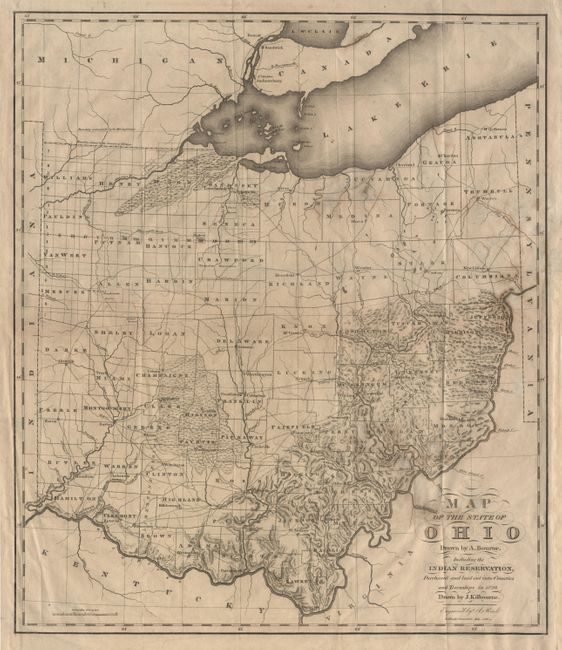
“Map of the State of Ohio including the Indian Reservation, Purchased and laid out into Counties and Townships in 1820”
Map Maker:
Bourne & Kilbourne
This scarce map resulted from the combined efforts... (full text available to subscribers)
| Item Detail |
| |
| |
MapMaker: |
Bourne & Kilbourne
|
|
| |
| |
Subject: |
Ohio |
|
| |
Period/Size: |
1820 / 19.0" x 16.2" (48.3 x 41.2 cm)
|
|
| |
Color: |
Black & White
|
|
| |
Condition: |
(B) Tissue repairs on a couple of folds and minor discoloration. (condition help) |
|
| |
Source: |
American Antiquarian Society "Archaelogia Americana" |
|
| |
References: |
Phillips (M) p. 627; Smith, The Mapping of Ohio #168. |
|
| |
|
|
| Sales Information |
| |
| |
Price: |
|
|
| |
| |
Offered by: |
Old World Auctions |
|
| |
Catalog: |
Auction No. 99 - Antique Maps, Charts, Atlases & Globes (304) |
|
| |
Lot/Item #: |
231 |
|
| |
| |
Date: |
06/2002
|
|
| |
| |
|
Antique Maps - Valuation and Pricing, Descriptions, Resources |
|
Home |
Information |
Search |
Register |
Contact Us |
Site Map
Americana Exchange, Inc. © 1999 - 2024 Americana Exchange, Inc.. All rights reserved.
OldMaps.com, the OldMaps.com logo and
AMPR are service marks or registered service marks of Americana Exchange, Inc..
|