Title:
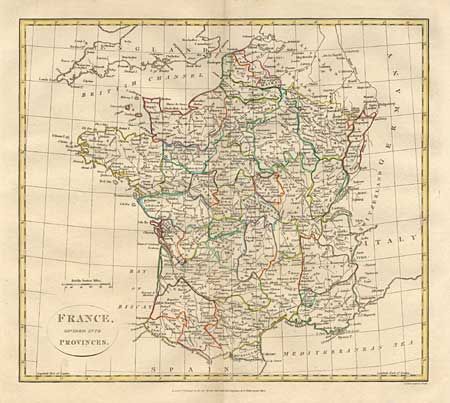
“France, divided into Provinces”
Map Maker:
Longman & Co.
Nicely engraved map that includes Flanders, Switze... (full text available to subscribers)
| Item Detail |
| |
| |
MapMaker: |
Longman & Co.
|
|
| |
| |
Subject: |
France |
|
| |
Period/Size: |
1808 / 13.4" x 15.2" (34.1 x 38.6 cm)
|
|
| |
Color: |
Colored
|
|
| |
Condition: |
(A) Good impression and wide margins. (condition help) |
|
| |
Source: |
Atlas to Cruttwell's Gazetteer |
|
| |
References: |
|
|
| |
|
|
| Sales Information |
| |
| |
Price: |
|
|
| |
| |
Offered by: |
Old World Auctions |
|
| |
Catalog: |
Auction No. 100 - Antique Maps, Charts, Atlases & Globes (333) |
|
| |
Lot/Item #: |
343 |
|
| |
| |
Date: |
09/2002
|
|
| |
| |
|
Antique Maps - Valuation and Pricing, Descriptions, Resources |
|
Home |
Information |
Search |
Register |
Contact Us |
Site Map
Americana Exchange, Inc. © 1999 - 2024 Americana Exchange, Inc.. All rights reserved.
OldMaps.com, the OldMaps.com logo and
AMPR are service marks or registered service marks of Americana Exchange, Inc..
|