Title:
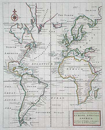
“A General Chart of the Sea Coast of Europe, Africa & America. According to E. Wrights or Mercator's Projection”
Map Maker:
Herman Moll
Very unusual map centered on the Atlantic Ocean, b... (full text available to subscribers)
| Item Detail |
| |
| |
MapMaker: |
Herman Moll
|
|
| |
| |
Subject: |
Atlantic |
|
| |
Period/Size: |
1720 / 14.0" x 11.0" (35.6 x 28.0 cm)
|
|
| |
Color: |
Colored
|
|
| |
Condition: |
(A) A tiny spot in South America, still very good with wide margins. (condition help) |
|
| |
Source: |
|
|
| |
References: |
Sabin #9205. |
|
| |
|
|
| Sales Information |
| |
| |
Price: |
|
|
| |
| |
Offered by: |
Old World Auctions |
|
| |
Catalog: |
Auction No. 100 - Antique Maps, Charts, Atlases & Globes (333) |
|
| |
Lot/Item #: |
268 |
|
| |
| |
Date: |
09/2002
|
|
| |
| |
|
Antique Maps - Valuation and Pricing, Descriptions, Resources |
|
Home |
Information |
Search |
Register |
Contact Us |
Site Map
Americana Exchange, Inc. © 1999 - 2024 Americana Exchange, Inc.. All rights reserved.
OldMaps.com, the OldMaps.com logo and
AMPR are service marks or registered service marks of Americana Exchange, Inc..
|