Title:
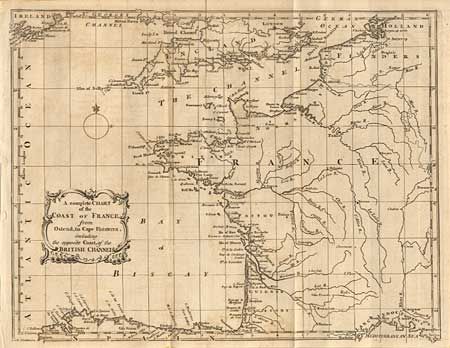
“A complete Chart of the Coast of France from Ostend, to Cape Finisterra, including the opposite Coast, of the British Channel”
Map Maker:
Anonymous
Good detail along the coast extending from Holland... (full text available to subscribers)
| Item Detail |
| |
| |
MapMaker: |
Anonymous
|
|
| |
| |
Subject: |
France |
|
| |
Period/Size: |
1758 / 7.8" x 10.0" (19.9 x 25.4 cm)
|
|
| |
Color: |
Black & White
|
|
| |
Condition: |
(B) Good impression on thick paper. Split on one fold, closed on verso with archival tape. (condition help) |
|
| |
Source: |
Gentleman's Magazine, |
|
| |
References: |
Jolly GENT-123. |
|
| |
|
|
| Sales Information |
| |
| |
Price: |
|
|
| |
| |
Offered by: |
Old World Auctions |
|
| |
Catalog: |
Auction No. 100 - Antique Maps, Charts, Atlases & Globes (333) |
|
| |
Lot/Item #: |
340 |
|
| |
| |
Date: |
09/2002
|
|
| |
| |
|
Antique Maps - Valuation and Pricing, Descriptions, Resources |
|
Home |
Information |
Search |
Register |
Contact Us |
Site Map
Americana Exchange, Inc. © 1999 - 2024 Americana Exchange, Inc.. All rights reserved.
OldMaps.com, the OldMaps.com logo and
AMPR are service marks or registered service marks of Americana Exchange, Inc..
|