| Item Detail |
| |
| |
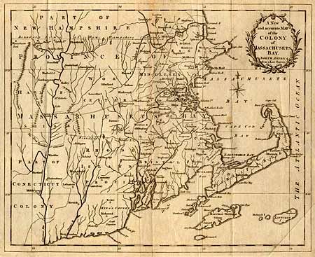
MapMaker: |
Anonymous
|
|
| |
| |
Subject: |
Colonial New England |
|
| |
Period/Size: |
1780 / 10.3" x 12.8" (26.2 x 32.6 cm)
|
|
| |
Color: |
Black & White
|
|
| |
Condition: |
(B) Some light spots and toning along fold. Binding trim with a small binding tear, repaired with archival tape. (condition help) |
|
| |
Source: |
Universal Magazine |
|
| |
References: |
Jolly, UNIV-190; McCorkle #780-12. |
|
| |
|
|
| Sales Information |
| |
| |
Price: |
|
|
| |
| |
Offered by: |
Old World Auctions |
|
| |
Catalog: |
Auction No. 100 - Antique Maps, Charts, Atlases & Globes (333) |
|
| |
Lot/Item #: |
116 |
|
| |
| |
Date: |
09/2002
|
|
| |
| |
|