Title:
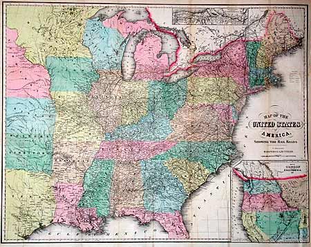
“Map of the United States of America, Showing the Rail Roads To Illustrate Harpers Gazetteer”
Map Maker:
John Calvin Smith [& Son]
A large inset shows the boundaries of Washington a... (full text available to subscribers)
| Item Detail |
| |
| |
MapMaker: |
John Calvin Smith [& Son]
|
|
| |
| |
Subject: |
United States |
|
| |
Period/Size: |
1855 / 21.0" x 27.0" (53.4 x 68.6 cm)
|
|
| |
Color: |
Colored
|
|
| |
Condition: |
(A) Backed with archival tissue, binding side margin reinforced with paper and a little toning along one fold, still very good. (condition help) |
|
| |
Source: |
Harpers Gazetteer |
|
| |
References: |
|
|
| |
|
|
| Sales Information |
| |
| |
Price: |
|
|
| |
| |
Offered by: |
Old World Auctions |
|
| |
Catalog: |
Auction No. 100 - Antique Maps, Charts, Atlases & Globes (333) |
|
| |
Lot/Item #: |
135 |
|
| |
| |
Date: |
09/2002
|
|
| |
| |
|
Antique Maps - Valuation and Pricing, Descriptions, Resources |
|
Home |
Information |
Search |
Register |
Contact Us |
Site Map
Americana Exchange, Inc. © 1999 - 2024 Americana Exchange, Inc.. All rights reserved.
OldMaps.com, the OldMaps.com logo and
AMPR are service marks or registered service marks of Americana Exchange, Inc..
|