Title:
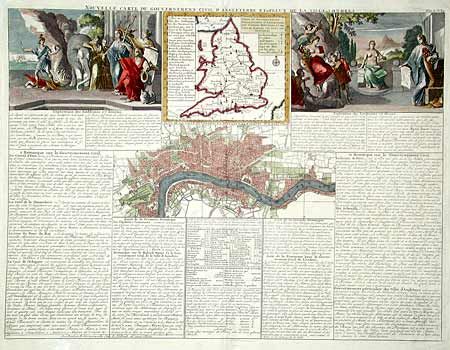
“Nouvelle Carte du Gouvernement civil d'Angleterre et de Celuy de la Ville de Londres”
Map Maker:
Henry Abraham Chatelain
Folio sheet containing a map of England and Wales ... (full text available to subscribers)
| Item Detail |
| |
| |
MapMaker: |
Henry Abraham Chatelain
|
|
| |
| |
Subject: |
England, London |
|
| |
Period/Size: |
1708 / 13.6" x 18.0" (34.6 x 45.8 cm)
|
|
| |
Color: |
Colored
|
|
| |
Condition: |
(A) Full recent color. Marginal tears repaired. (condition help) |
|
| |
Source: |
Atlas Historique |
|
| |
References: |
Phillips (A) #548; Howgego 47. |
|
| |
|
|
| Sales Information |
| |
| |
Price: |
|
|
| |
| |
Offered by: |
Old World Auctions |
|
| |
Catalog: |
Auction No. 100 - Antique Maps, Charts, Atlases & Globes (333) |
|
| |
Lot/Item #: |
295 |
|
| |
| |
Date: |
09/2002
|
|
| |
| |
|
Antique Maps - Valuation and Pricing, Descriptions, Resources |
|
Home |
Information |
Search |
Register |
Contact Us |
Site Map
Americana Exchange, Inc. © 1999 - 2024 Americana Exchange, Inc.. All rights reserved.
OldMaps.com, the OldMaps.com logo and
AMPR are service marks or registered service marks of Americana Exchange, Inc..
|