Title:
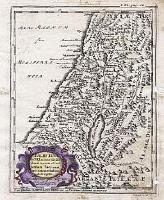
“Palestinae in XII tribus divisae”
Map Maker:
Carlo Ludovico de Launay
From a rare book by Charles Louis de Launay titled... (full text available to subscribers)
| Item Detail |
| |
| |
MapMaker: |
Carlo Ludovico de Launay
|
|
| |
| |
Subject: |
Holy Land |
|
| |
Period/Size: |
1738 / 7.1" x 5.1" (18.0 x 13.0 cm)
|
|
| |
Color: |
Black & White
|
|
| |
Condition: |
Worming in right margin just entering border. Soiling lower right corner. Repaired tears in bottom margin. Faint ink denoting compass direction in margins. (condition help) |
|
| |
Source: |
|
|
| |
References: |
None found |
|
| |
|
|
| Sales Information |
| |
| |
Price: |
|
|
| |
| |
Offered by: |
Paulus Swaen Old Maps & Prints |
|
| |
Catalog: |
Internet Auction November 2000 (343) |
|
| |
Lot/Item #: |
06676 |
|
| |
| |
Date: |
11/2000
|
|
| |
| |
|
Antique Maps - Valuation and Pricing, Descriptions, Resources |
|
Home |
Information |
Search |
Register |
Contact Us |
Site Map
Americana Exchange, Inc. © 1999 - 2024 Americana Exchange, Inc.. All rights reserved.
OldMaps.com, the OldMaps.com logo and
AMPR are service marks or registered service marks of Americana Exchange, Inc..
|