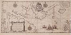
Title:
“Tabula Nautica, qua repraesentantur orae maritimae.”
Map Maker:
Theodore de Bry
First map to depict Hudson bay, prepared by Hessel... (full text available to subscribers)
| Item Detail |
| |
| |
MapMaker: |
Theodore de Bry
|
|
| |
| |
Subject: |
Canada |
|
| |
Period/Size: |
1613 / 5.9" x 13.1" (15.0 x 33.2 cm)
|
|
| |
Color: |
Black & White
|
|
| |
Condition: |
In good condition, dark impression. Right hand margin cut close as issued. (condition help) |
|
| |
Source: |
|
|
| |
References: |
Burden, America 162. |
|
| |
|
|
| Sales Information |
| |
| |
Price: |
|
|
| |
| |
Offered by: |
Paulus Swaen Old Maps & Prints |
|
| |
Catalog: |
Internet Auction November 2000 (343) |
|
| |
Lot/Item #: |
06481 |
|
| |
| |
Date: |
11/2000
|
|
| |
| |
|
Antique Maps - Valuation and Pricing, Descriptions, Resources |
|
Home |
Information |
Search |
Register |
Contact Us |
Site Map
Americana Exchange, Inc. © 1999 - 2024 Americana Exchange, Inc.. All rights reserved.
OldMaps.com, the OldMaps.com logo and
AMPR are service marks or registered service marks of Americana Exchange, Inc..
|