Title:
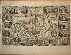
“Tabula Geographica, in qua Israelitarum”
Map Maker:
Plancius/Cloppenburg
This is the second state of the Petrus Plancius bi... (full text available to subscribers)
| Item Detail |
| |
| |
MapMaker: |
Plancius/Cloppenburg
|
|
| |
| |
Subject: |
Holy Land |
|
| |
Period/Size: |
1643 / 11.4" x 19.3" (29.0 x 49.0 cm)
|
|
| |
Color: |
Black & White
|
|
| |
Condition: |
The condition of the map is very good, the margins left and right about 5 mms, top and bottom 5 cms. (condition help) |
|
| |
Source: |
|
|
| |
References: |
Poortman/Augusteijn # 76 |
|
| |
|
|
| Sales Information |
| |
| |
Price: |
|
|
| |
| |
Offered by: |
Paulus Swaen Old Maps & Prints |
|
| |
Catalog: |
Internet Auction September 2000 (342) |
|
| |
Lot/Item #: |
06380 |
|
| |
| |
Date: |
09/2000
|
|
| |
| |
|
Antique Maps - Valuation and Pricing, Descriptions, Resources |
|
Home |
Information |
Search |
Register |
Contact Us |
Site Map
Americana Exchange, Inc. © 1999 - 2024 Americana Exchange, Inc.. All rights reserved.
OldMaps.com, the OldMaps.com logo and
AMPR are service marks or registered service marks of Americana Exchange, Inc..
|