Title:
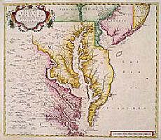
“A new map of Virginia Maryland…”
Map Maker:
Christopher Browne
An uncommon example of one of the few English maps... (full text available to subscribers)
| Item Detail |
| |
| |
MapMaker: |
Christopher Browne
|
|
| |
| |
Subject: |
Colonial Southeast |
|
| |
Period/Size: |
1721 / 19.0" x 21.8" (48.3 x 55.4 cm)
|
|
| |
Color: |
Colored
|
|
| |
Condition: |
A good and dark impression. Split along centre fold expertly repaired. Centre fold backed for protective reason. (condition help) |
|
| |
Source: |
|
|
| |
References: |
Papenfuse & Coale, Atlas of hist. maps of Maryland, pp 19-21 |
|
| |
|
|
| Sales Information |
| |
| |
Price: |
|
|
| |
| |
Offered by: |
Paulus Swaen Old Maps & Prints |
|
| |
Catalog: |
Internet Auction November 1999 (339) |
|
| |
Lot/Item #: |
05091 |
|
| |
| |
Date: |
11/1999
|
|
| |
| |
|
Antique Maps - Valuation and Pricing, Descriptions, Resources |
|
Home |
Information |
Search |
Register |
Contact Us |
Site Map
Americana Exchange, Inc. © 1999 - 2024 Americana Exchange, Inc.. All rights reserved.
OldMaps.com, the OldMaps.com logo and
AMPR are service marks or registered service marks of Americana Exchange, Inc..
|