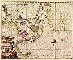
| Item Detail |
| |
| |
MapMaker: |
Frederick de Wit
|
|
| |
| |
Subject: |
Asia - Southeast |
|
| |
Period/Size: |
1660 / 17.3" x 21.3" (44.0 x 54.0 cm)
|
|
| |
Color: |
Colored
|
|
| |
Condition: |
Paper on several places underlaid due to oxidation of green paint, mainly for protective reason. In the island Borneo, on two places, paper re-inforced. For the rest a fine copy. Printed on heavy paper. (condition help) |
|
| |
Source: |
|
|
| |
References: |
Tooley, Mapping of Australia, page 205, #40, plate 100; Clancy, The mapping of Terra Australis, map 6.13. |
|
| |
|
|
| Sales Information |
| |
| |
Price: |
|
|
| |
| |
Offered by: |
Paulus Swaen Old Maps & Prints |
|
| |
Catalog: |
Internet Auction September 2000 (342) |
|
| |
Lot/Item #: |
02442 |
|
| |
| |
Date: |
09/2000
|
|
| |
| |
|


