Title:
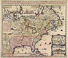
“Carte de la Nouvelle France, ou se voi le cours…”
Map Maker:
Henry Abraham Chatelain
Derived from de Fer's 1718 map, from west of the M... (full text available to subscribers)
| Item Detail |
| |
| |
MapMaker: |
Henry Abraham Chatelain
|
|
| |
| |
Subject: |
Colonial North America |
|
| |
Period/Size: |
1719 / 16.6" x 19.1" (42.1 x 48.4 cm)
|
|
| |
Color: |
Colored
|
|
| |
Condition: |
A good and dark impression in attractive colours. (condition help) |
|
| |
Source: |
|
|
| |
References: |
|
|
| |
|
|
| Sales Information |
| |
| |
Price: |
|
|
| |
| |
Offered by: |
Paulus Swaen Old Maps & Prints |
|
| |
Catalog: |
Internet Auction March 1999 (338) |
|
| |
Lot/Item #: |
00314 |
|
| |
| |
Date: |
03/1999
|
|
| |
| |
|
Antique Maps - Valuation and Pricing, Descriptions, Resources |
|
Home |
Information |
Search |
Register |
Contact Us |
Site Map
Americana Exchange, Inc. © 1999 - 2024 Americana Exchange, Inc.. All rights reserved.
OldMaps.com, the OldMaps.com logo and
AMPR are service marks or registered service marks of Americana Exchange, Inc..
|