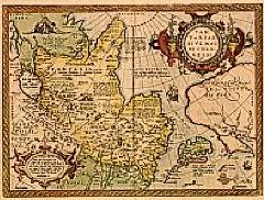
Title:
“Tartariae sive magni Chami regni typus.”
Map Maker:
Abraham Ortelius
Much of the information shown on this map relates ... (full text available to subscribers)
| Item Detail |
| |
| |
MapMaker: |
Abraham Ortelius
|
|
| |
| |
Subject: |
North Pacific Ocean |
|
| |
Period/Size: |
1570-1612 / 13.8" x 18.5" (35.0 x 47.1 cm)
|
|
| |
Color: |
Colored
|
|
| |
Condition: |
Repair of a marginal tear lower left hand corner, 1cm into engraved area. With some discolouration due to use of tape. (condition help) |
|
| |
Source: |
|
|
| |
References: |
Broecke, Ortelius 163 |
|
| |
|
|
| Sales Information |
| |
| |
Price: |
|
|
| |
| |
Offered by: |
Paulus Swaen Old Maps & Prints |
|
| |
Catalog: |
Internet Auction March 2000 (340) |
|
| |
Lot/Item #: |
00916 |
|
| |
| |
Date: |
03/2000
|
|
| |
| |
|
Antique Maps - Valuation and Pricing, Descriptions, Resources |
|
Home |
Information |
Search |
Register |
Contact Us |
Site Map
Americana Exchange, Inc. © 1999 - 2024 Americana Exchange, Inc.. All rights reserved.
OldMaps.com, the OldMaps.com logo and
AMPR are service marks or registered service marks of Americana Exchange, Inc..
|