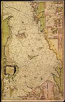
Title:
“A new chart of the Cattegat..”
Map Maker:
Laurie & Whittle
Large scale chart of Kattegat prepared in 1790 by ... (full text available to subscribers)
| Item Detail |
| |
| |
MapMaker: |
Laurie & Whittle
|
|
| |
| |
Subject: |
Denmark |
|
| |
Period/Size: |
1794 / 40.6" x 25.4" (103.0 x 64.6 cm)
|
|
| |
Color: |
Colored
|
|
| |
Condition: |
Repair of several marginal tears, some affecting the engraved area, hardly visible. Regarding its size in good condition. (condition help) |
|
| |
Source: |
|
|
| |
References: |
|
|
| |
|
|
| Sales Information |
| |
| |
Price: |
|
|
| |
| |
Offered by: |
Paulus Swaen Old Maps & Prints |
|
| |
Catalog: |
Internet Auction November 2000 (343) |
|
| |
Lot/Item #: |
04874 |
|
| |
| |
Date: |
11/2000
|
|
| |
| |
|
Antique Maps - Valuation and Pricing, Descriptions, Resources |
|
Home |
Information |
Search |
Register |
Contact Us |
Site Map
Americana Exchange, Inc. © 1999 - 2024 Americana Exchange, Inc.. All rights reserved.
OldMaps.com, the OldMaps.com logo and
AMPR are service marks or registered service marks of Americana Exchange, Inc..
|