Rister or Sign In to see pricing information


Title:

No.3. Map of the Harbor of St. Louis, Mississippi River. Oct. 1837

Map Maker:

Robert Edward Lee

No.3. Map of the Harbor of St. Louis, Mississippi River. Oct. 1837

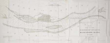
Surveyed by Lt. R.E. Lee. Shows a street p... (full text available to subscribers)
Item Detail
 
  MapMaker:  

Robert Edward Lee


  Subject:  Illinois  
  Period/Size:  1837 / 16.0" x 41.0"  (40.7 x 104.2 cm)  
  Color:  Black & White  
  Condition:  (A) Folding, as issued. Foxed at first panel fold and along top, still very good. (condition help)  
  Source:  Ex Senate doc 139. 25th congress 2nd Session  
  References:  Koepp #316.  
 
 
Sales Information
 
  Price: 

Please register your email to view records, or sign in with email address to see records


  Offered by:  Old World Auctions  
  Catalog:  Auction No. 101 - Antique Maps, Charts, Atlases & Globes (348)  
  Lot/Item #:  175  
 
  Date:  12/2002  


Antique Maps - Valuation and Pricing, Descriptions, Resources


Home | Information | Search | Register | Contact Us | Site Map

Americana Exchange, Inc. © 1999 - 2024 Americana Exchange, Inc.. All rights reserved. OldMaps.com, the OldMaps.com logo and
AMPR are service marks or registered service marks of Americana Exchange, Inc..