Title:
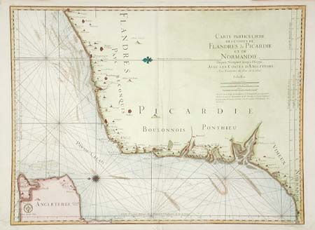
“Carte Particuliere Des Costs De Flandres de Picardie et de Normandie, Depuis Nieuport jusqua Dieppe, Avec Les Costes d'Angleterre...”
Map Maker:
Depot de la Marine
Finely detailed sea chart of the Straight of Dover... (full text available to subscribers)
| Item Detail |
| |
| |
MapMaker: |
Depot de la Marine
|
|
| |
| |
Subject: |
English Channel |
|
| |
Period/Size: |
1793 / 23.5" x 31.7" (59.7 x 80.6 cm)
|
|
| |
Color: |
Colored
|
|
| |
Condition: |
(A) Fine heavy paper with faint damp stain in lower margin. Slight soft crease along fold. (condition help) |
|
| |
Source: |
|
|
| |
References: |
|
|
| |
|
|
| Sales Information |
| |
| |
Price: |
|
|
| |
| |
Offered by: |
Old World Auctions |
|
| |
Catalog: |
Auction No. 101 - Antique Maps, Charts, Atlases & Globes (348) |
|
| |
Lot/Item #: |
284 |
|
| |
| |
Date: |
12/2002
|
|
| |
| |
|
Antique Maps - Valuation and Pricing, Descriptions, Resources |
|
Home |
Information |
Search |
Register |
Contact Us |
Site Map
Americana Exchange, Inc. © 1999 - 2024 Americana Exchange, Inc.. All rights reserved.
OldMaps.com, the OldMaps.com logo and
AMPR are service marks or registered service marks of Americana Exchange, Inc..
|