Title:
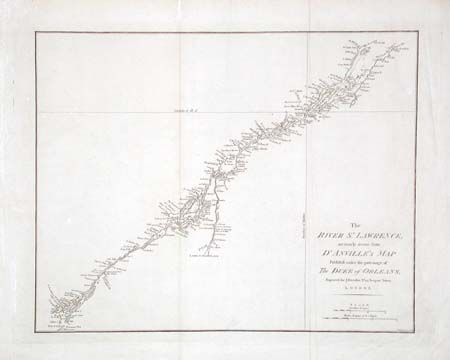
“The River St. Lawrence, accurately drawn from D'Anville's Map…”
Map Maker:
John E. Harrison
Sparse map of the St. Lawrence River from Lake Ont... (full text available to subscribers)
| Item Detail |
| |
| |
MapMaker: |
John E. Harrison
|
|
| |
| |
Subject: |
Canada |
|
| |
Period/Size: |
1784 / 13.1" x 16.5" (33.3 x 42.0 cm)
|
|
| |
Color: |
Black & White
|
|
| |
Condition: |
(B) Tissue repair of short separation on fold, a few faint spots. (condition help) |
|
| |
Source: |
|
|
| |
References: |
Kershaw #681; Sellers & Van Ee #251. |
|
| |
|
|
| Sales Information |
| |
| |
Price: |
|
|
| |
| |
Offered by: |
Old World Auctions |
|
| |
Catalog: |
Auction No. 101 - Antique Maps, Charts, Atlases & Globes (348) |
|
| |
Lot/Item #: |
111 |
|
| |
| |
Date: |
12/2002
|
|
| |
| |
|
Antique Maps - Valuation and Pricing, Descriptions, Resources |
|
Home |
Information |
Search |
Register |
Contact Us |
Site Map
Americana Exchange, Inc. © 1999 - 2024 Americana Exchange, Inc.. All rights reserved.
OldMaps.com, the OldMaps.com logo and
AMPR are service marks or registered service marks of Americana Exchange, Inc..
|