Rister or Sign In to see pricing information


Title:

A Map of the British Empire in America, from the Head of Hudsons Bay to the Southern bounds of Georgia, with the intervention of Canada

Map Maker:

Anonymous

A Map of the British Empire in America, from the Head of Hudsons Bay to the Southern bounds of Georgia, with the intervention of Canada

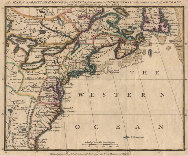
Fascinating map covering from the Gulf of St. Lawr... (full text available to subscribers)
Item Detail
 
  MapMaker:  

Anonymous


  Subject:  Colonial North America  
  Period/Size:  1750 / 9.5" x 11.8"  (24.2 x 30.0 cm)  
  Color:  Colored  
  Condition:  (A) Tiny tear at binding side, just entering neatline, repaired with tissue on verso. (condition help)  
  Source:  Owen's Magazine of Magazines  
  References:  Jolly #MOM-2; McCorkle #750-3; Kershaw #341.  
 
 
Sales Information
 
  Price: 

Please register your email to view records, or sign in with email address to see records


  Offered by:  Old World Auctions  
  Catalog:  Auction No. 101 - Antique Maps, Charts, Atlases & Globes (348)  
  Lot/Item #:  097  
 
  Date:  12/2002  


Antique Maps - Valuation and Pricing, Descriptions, Resources


Home | Information | Search | Register | Contact Us | Site Map

Americana Exchange, Inc. © 1999 - 2024 Americana Exchange, Inc.. All rights reserved. OldMaps.com, the OldMaps.com logo and
AMPR are service marks or registered service marks of Americana Exchange, Inc..