Title:
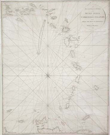
“A New and Improved Chart of the West India or Carribbee Islands drawn from the Best Authorities by William Heather 1795”
Map Maker:
William Heather
Large, scarce navigation chart showing West Indies... (full text available to subscribers)
| Item Detail |
| |
| |
MapMaker: |
William Heather
|
|
| |
| |
Subject: |
Caribbean |
|
| |
Period/Size: |
1795 / 30.8" x 24.7" (78.3 x 62.8 cm)
|
|
| |
Color: |
Black & White
|
|
| |
Condition: |
(B) Backed with blue paper as issued. Some repairs in margins and just inside border and some creasing. In remarkably good condition for a working sea chart. (condition help) |
|
| |
Source: |
|
|
| |
References: |
|
|
| |
|
|
| Sales Information |
| |
| |
Price: |
|
|
| |
| |
Offered by: |
Old World Auctions |
|
| |
Catalog: |
Auction No. 101 - Antique Maps, Charts, Atlases & Globes (348) |
|
| |
Lot/Item #: |
219 |
|
| |
| |
Date: |
12/2002
|
|
| |
| |
|
Antique Maps - Valuation and Pricing, Descriptions, Resources |
|
Home |
Information |
Search |
Register |
Contact Us |
Site Map
Americana Exchange, Inc. © 1999 - 2024 Americana Exchange, Inc.. All rights reserved.
OldMaps.com, the OldMaps.com logo and
AMPR are service marks or registered service marks of Americana Exchange, Inc..
|