Title:
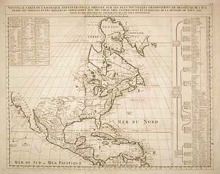
“Nouvelle Carte de l' Amerique Septentrionale dressee sur les plus Nouvelles Observations de Messieurs de l' Academie des Sciences et des Meilleurs Geographes avec des tables tres instructives et curieuses de la division de tous les Etats…”
Map Maker:
Henry Abraham Chatelain
Fine folio map covering the region from northern V... (full text available to subscribers)
| Item Detail |
| |
| |
MapMaker: |
Henry Abraham Chatelain
|
|
| |
| |
Subject: |
North America |
|
| |
Period/Size: |
1705 / 18.5" x 23.3" (47.0 x 59.2 cm)
|
|
| |
Color: |
Black & White
|
|
| |
Condition: |
(B) Good impression on a fine sheet of hand-laid paper with watermark and full margins. Very tiny hole in Bahamas. (condition help) |
|
| |
Source: |
Atlas Historique |
|
| |
References: |
Lowery #263; Phillips (A) 579. |
|
| |
|
|
| Sales Information |
| |
| |
Price: |
|
|
| |
| |
Offered by: |
Old World Auctions |
|
| |
Catalog: |
Auction No. 102 - Antique Maps, Charts, Atlases & Globes (349) |
|
| |
Lot/Item #: |
092 |
|
| |
| |
Date: |
03/2003
|
|
| |
| |
|
Antique Maps - Valuation and Pricing, Descriptions, Resources |
|
Home |
Information |
Search |
Register |
Contact Us |
Site Map
Americana Exchange, Inc. © 1999 - 2024 Americana Exchange, Inc.. All rights reserved.
OldMaps.com, the OldMaps.com logo and
AMPR are service marks or registered service marks of Americana Exchange, Inc..
|