Title:
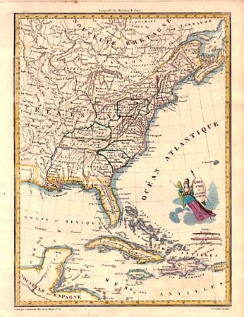
“Etats Unis et Grandes Antilles”
Map Maker:
Jean Baptiste Marie Chamouin
Early nineteenth century map showing the United St... (full text available to subscribers)
| Item Detail |
| |
| |
MapMaker: |
Jean Baptiste Marie Chamouin
|
|
| |
| |
Subject: |
Eastern United States and Caribbean |
|
| |
Period/Size: |
1805 / 11.7" x 8.6" (29.8 x 21.9 cm)
|
|
| |
Color: |
Colored
|
|
| |
Condition: |
(A) A few unobtrusive spots in blank margins. (condition help) |
|
| |
Source: |
|
|
| |
References: |
|
|
| |
|
|
| Sales Information |
| |
| |
Price: |
|
|
| |
| |
Offered by: |
Old World Auctions |
|
| |
Catalog: |
Auction No. 102 - Antique Maps, Charts, Atlases & Globes (349) |
|
| |
Lot/Item #: |
141 |
|
| |
| |
Date: |
03/2003
|
|
| |
| |
|
Antique Maps - Valuation and Pricing, Descriptions, Resources |
|
Home |
Information |
Search |
Register |
Contact Us |
Site Map
Americana Exchange, Inc. © 1999 - 2024 Americana Exchange, Inc.. All rights reserved.
OldMaps.com, the OldMaps.com logo and
AMPR are service marks or registered service marks of Americana Exchange, Inc..
|