Title:
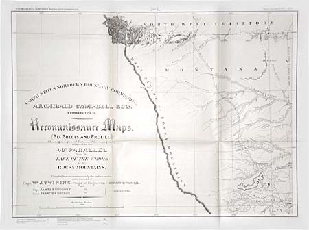
“Reconnaissance Maps. (Six Sheets and Profile) Showing the general features of the topography adjacent to the 49th Parallel from the Lake of the Woods to the Rocky Mountains”
Map Maker:
U.S. Government
Complete and matching set of all six maps, each si... (full text available to subscribers)
| Item Detail |
| |
| |
MapMaker: |
U.S. Government
|
|
| |
| |
Subject: |
United States - Northern Midwest |
|
| |
Period/Size: |
1878 / 15.3" x 21.0" (38.9 x 53.4 cm)
|
|
| |
Color: |
Colored
|
|
| |
Condition: |
(A+) Last sheet has mis-folded area affecting only the margin. (condition help) |
|
| |
Source: |
Senate ex doc 41, 44th Cong., 2nd Sess. |
|
| |
References: |
Wheat (TMW) #1289. |
|
| |
|
|
| Sales Information |
| |
| |
Price: |
|
|
| |
| |
Offered by: |
Old World Auctions |
|
| |
Catalog: |
Auction No. 102 - Antique Maps, Charts, Atlases & Globes (349) |
|
| |
Lot/Item #: |
152 |
|
| |
| |
Date: |
03/2003
|
|
| |
| |
|
Antique Maps - Valuation and Pricing, Descriptions, Resources |
|
Home |
Information |
Search |
Register |
Contact Us |
Site Map
Americana Exchange, Inc. © 1999 - 2024 Americana Exchange, Inc.. All rights reserved.
OldMaps.com, the OldMaps.com logo and
AMPR are service marks or registered service marks of Americana Exchange, Inc..
|