Title:
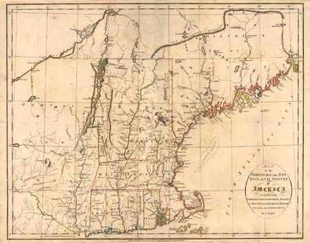
“Map of the Northern, or, New England States of America, Comprehending Vermont, New Hampshire, District of Main, Massachusetts, Rhode Island, and Connecticut.”
Map Maker:
John Russell
A very attractive copper engraved map of New Engla... (full text available to subscribers)
| Item Detail |
| |
| |
MapMaker: |
John Russell
|
|
| |
| |
Subject: |
New England |
|
| |
Period/Size: |
1795 / 14.5" x 18.2" (36.9 x 46.3 cm)
|
|
| |
Color: |
Colored
|
|
| |
Condition: |
(B) Nicely engraved with original outline color. Small old repair on verso, minor surface soil as well as some light, scattered foxing. (condition help) |
|
| |
Source: |
Historical, Geographical ...View of the United States |
|
| |
References: |
McCorkle #795.9. |
|
| |
|
|
| Sales Information |
| |
| |
Price: |
|
|
| |
| |
Offered by: |
Old World Auctions |
|
| |
Catalog: |
Auction No. 102 - Antique Maps, Charts, Atlases & Globes (349) |
|
| |
Lot/Item #: |
144 |
|
| |
| |
Date: |
03/2003
|
|
| |
| |
|
Antique Maps - Valuation and Pricing, Descriptions, Resources |
|
Home |
Information |
Search |
Register |
Contact Us |
Site Map
Americana Exchange, Inc. © 1999 - 2024 Americana Exchange, Inc.. All rights reserved.
OldMaps.com, the OldMaps.com logo and
AMPR are service marks or registered service marks of Americana Exchange, Inc..
|