Rister or Sign In to see pricing information


Title:

Map of that Portion of the Boundary Between the United States and Mexico from the Pacific Coast to the Junction of the Gila and Colorado Rivers…

Map Maker:

U.S. Government

Map of that Portion of the Boundary Between the United States and Mexico from the Pacific Coast to the Junction of the Gila and Colorado Rivers…

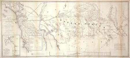
Surveyed Under the Direction of Hon. John B. Wheel... (full text available to subscribers)
Item Detail
 
  MapMaker:  

U.S. Government


  Subject:  Southwestern United States & Mexico  
  Period/Size:  1855 / 21.0" x 49.0"  (53.4 x 124.5 cm)  
  Color:  Black & White  
  Condition:  (A) Lightly toned along folds. Backed with archival tissue. (condition help)  
  Source:  Senate Doc. #55, 33rd Cong., 2nd Sess.  
  References:  Wheat (TMW) #821.  
 
 
Sales Information
 
  Price: 

Please register your email to view records, or sign in with email address to see records


  Offered by:  Old World Auctions  
  Catalog:  Auction No. 102 - Antique Maps, Charts, Atlases & Globes (349)  
  Lot/Item #:  177  
 
  Date:  03/2003  


Antique Maps - Valuation and Pricing, Descriptions, Resources


Home | Information | Search | Register | Contact Us | Site Map

Americana Exchange, Inc. © 1999 - 2024 Americana Exchange, Inc.. All rights reserved. OldMaps.com, the OldMaps.com logo and
AMPR are service marks or registered service marks of Americana Exchange, Inc..