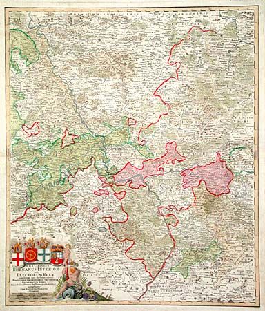
Title:
“S.R.I. Circulus Rhenanus Inferior sive Electorum Rheni…”
Map Maker:
Johann Baptist Homann
Highly detailed copper engraved map of central Ger... (full text available to subscribers)
| Item Detail |
| |
| |
MapMaker: |
Johann Baptist Homann
|
|
| |
| |
Subject: |
Germany |
|
| |
Period/Size: |
1730 / 22.5" x 19.1" (57.2 x 48.6 cm)
|
|
| |
Color: |
Colored
|
|
| |
Condition: |
(B) Old paper repair paper edge along fold, else very good. (condition help) |
|
| |
Source: |
Maior Atlas Acholaticus |
|
| |
References: |
|
|
| |
|
|
| Sales Information |
| |
| |
Price: |
|
|
| |
| |
Offered by: |
Old World Auctions |
|
| |
Catalog: |
Auction No. 102 - Antique Maps, Charts, Atlases & Globes (349) |
|
| |
Lot/Item #: |
392 |
|
| |
| |
Date: |
03/2003
|
|
| |
| |
|
Antique Maps - Valuation and Pricing, Descriptions, Resources |
|
Home |
Information |
Search |
Register |
Contact Us |
Site Map
Americana Exchange, Inc. © 1999 - 2024 Americana Exchange, Inc.. All rights reserved.
OldMaps.com, the OldMaps.com logo and
AMPR are service marks or registered service marks of Americana Exchange, Inc..
|