Rister or Sign In to see pricing information


Title:

Plan de la Ville et des Faubourgs De Rouen, leve par M. M. les Ingenieurs des Ponts et Chausees. . .

Map Maker:

Jean Lattre

Plan de la Ville et des Faubourgs De Rouen, leve par M. M. les Ingenieurs des Ponts et Chausees. . .

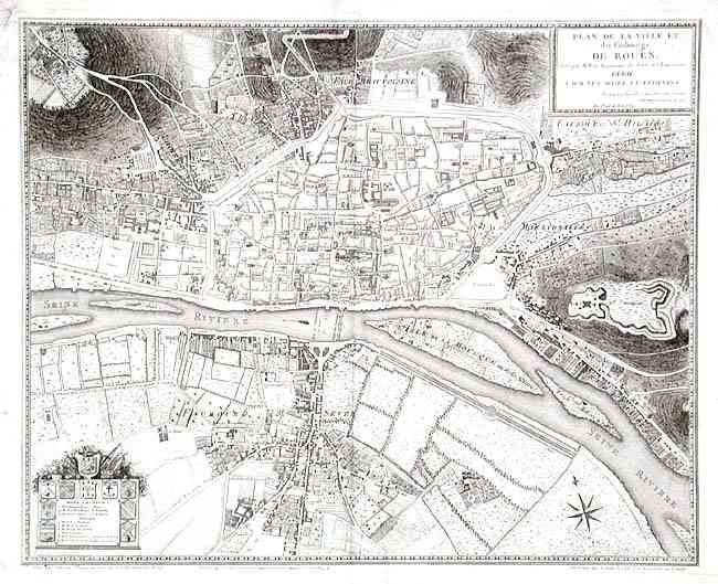
Handsomely engraved map of Rouen (Haute-Normandie)... (full text available to subscribers)
Item Detail
 
  MapMaker:  

Jean Lattre


  Subject:  France  
  Period/Size:  1784 / 17.1" x 21.4"  (43.5 x 54.4 cm)  
  Color:  Black & White  
  Condition:  (B) Lightly misfolded-folded along center. Marginal flaws: tidemarks and a couple of stains, short tear next to centerfold. Map very good except for a few spots. (condition help)  
  Source:   
  References:   
 
 
Sales Information
 
  Price: 

Please register your email to view records, or sign in with email address to see records


  Offered by:  Old World Auctions  
  Catalog:  Auction No. 103 - Antique Maps, Charts, Atlases & Globes (350)  
  Lot/Item #:  368  
 
  Date:  06/2003  


Antique Maps - Valuation and Pricing, Descriptions, Resources


Home | Information | Search | Register | Contact Us | Site Map

Americana Exchange, Inc. © 1999 - 2024 Americana Exchange, Inc.. All rights reserved. OldMaps.com, the OldMaps.com logo and
AMPR are service marks or registered service marks of Americana Exchange, Inc..