Rister or Sign In to see pricing information


Title:

De Zee Custen van Ruslandt, Laplant, Finmarcken, Spitsbergen en Nova Zemla

Map Maker:

Pieter Goos

De Zee Custen van Ruslandt, Laplant, Finmarcken, Spitsbergen en Nova Zemla

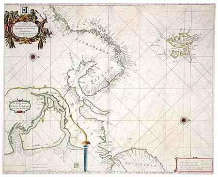
Fine sea chart of the Barents Sea covering the coa... (full text available to subscribers)
Item Detail
 
  MapMaker:  

Pieter Goos


  Subject:  Barents Sea  
  Period/Size:  1680 / 17.5" x 21.5"  (44.5 x 54.7 cm)  
  Color:  Colored  
  Condition:  (B) Pleasant outline coloring with fully colored cartouches. Tissue reinforced centerfold. Narrow, but adequate, margins with edges slightly chipped. (condition help)  
  Source:  Zee Atlas  
  References:   
 
 
Sales Information
 
  Price: 

Please register your email to view records, or sign in with email address to see records


  Offered by:  Old World Auctions  
  Catalog:  Auction No. 103 - Antique Maps, Charts, Atlases & Globes (350)  
  Lot/Item #:  286  
 
  Date:  06/2003  


Antique Maps - Valuation and Pricing, Descriptions, Resources


Home | Information | Search | Register | Contact Us | Site Map

Americana Exchange, Inc. © 1999 - 2024 Americana Exchange, Inc.. All rights reserved. OldMaps.com, the OldMaps.com logo and
AMPR are service marks or registered service marks of Americana Exchange, Inc..