Rister or Sign In to see pricing information


Title:

Carte des Etats-Unis d'Amerique et du Cours du Mississipi

Map Maker:

Louis Brion de la Tour

Carte des Etats-Unis d'Amerique et du Cours du Mississipi

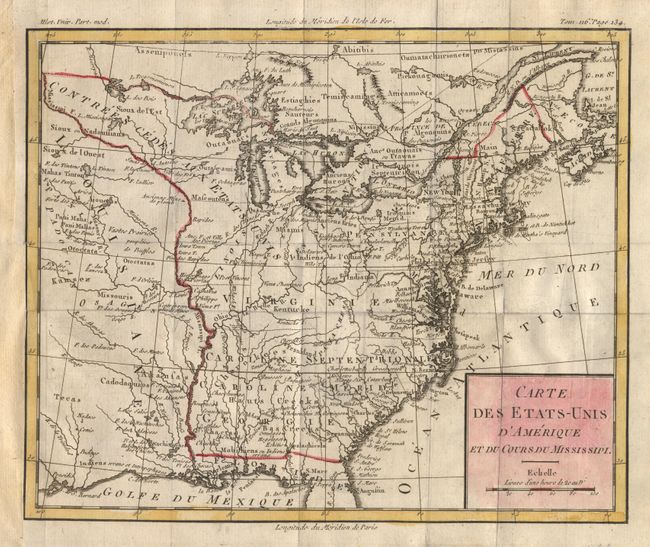
A fascinating map of the infant United States fill... (full text available to subscribers)
Item Detail
 
  MapMaker:  

Louis Brion de la Tour


  Subject:  Eastern United States  
  Period/Size:  1785 / 8.7" x 10.5"  (22.1 x 26.7 cm)  
  Color:  Colored  
  Condition:  (A) Folds as issued. Remargined along left binding side, right up to neatline with tiny loss. (condition help)  
  Source:  Histoire Universelle  
  References:  Baynton-Williams (TMC-72) #3.  
 
 
Sales Information
 
  Price: 

Please register your email to view records, or sign in with email address to see records


  Offered by:  Old World Auctions  
  Catalog:  Auction No. 103 - Antique Maps, Charts, Atlases & Globes (350)  
  Lot/Item #:  121  
 
  Date:  06/2003  


Antique Maps - Valuation and Pricing, Descriptions, Resources


Home | Information | Search | Register | Contact Us | Site Map

Americana Exchange, Inc. © 1999 - 2024 Americana Exchange, Inc.. All rights reserved. OldMaps.com, the OldMaps.com logo and
AMPR are service marks or registered service marks of Americana Exchange, Inc..