Rister or Sign In to see pricing information


Title:

Carte Physique de l' Ocean ou l' on voit des Grandes Chaines de Montagnes qui traversent les Continents d' Europe, d' Afrique et d' Amerique...

Map Maker:

Philip Buache

Carte Physique de l' Ocean ou l' on voit des Grandes Chaines de Montagnes qui traversent les Continents d' Europe, d' Afrique et d' Amerique...

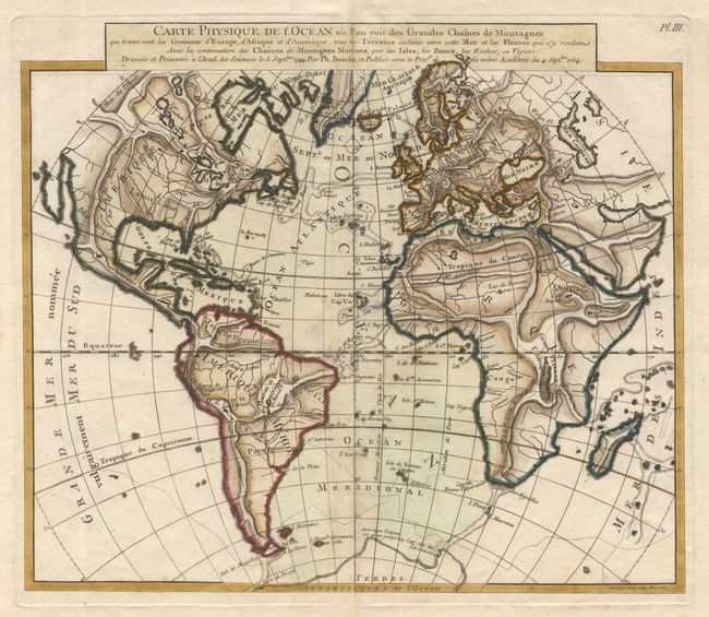
Unusual world map that was issued in a series by P... (full text available to subscribers)
Item Detail
 
  MapMaker:  

Philip Buache


  Subject:  World  
  Period/Size:  1757 / 11.7" x 13.6"  (29.8 x 34.6 cm)  
  Color:  Colored  
  Condition:  (B) On fine paper with wide margins and numerous watermarks. Finely colored. A few slight spots and trace of toning along centerfold, else very good. (condition help)  
  Source:   
  References:   
 
 
Sales Information
 
  Price: 

Please register your email to view records, or sign in with email address to see records


  Offered by:  Old World Auctions  
  Catalog:  Auction No. 103 - Antique Maps, Charts, Atlases & Globes (350)  
  Lot/Item #:  026  
 
  Date:  06/2003  


Antique Maps - Valuation and Pricing, Descriptions, Resources


Home | Information | Search | Register | Contact Us | Site Map

Americana Exchange, Inc. © 1999 - 2024 Americana Exchange, Inc.. All rights reserved. OldMaps.com, the OldMaps.com logo and
AMPR are service marks or registered service marks of Americana Exchange, Inc..