Title:
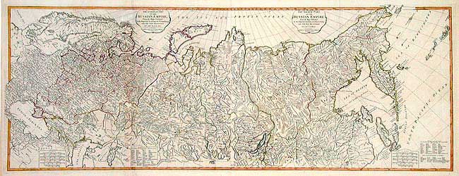
“The European Part of the Russian Empire... with the New Provinces of the Black Sea / The Asiatic Part of the Russian Empire… with the New Discoveries of Captn. Cook”
Map Maker:
Thomas Jefferys
Pair of large maps covering the region from Scandi... (full text available to subscribers)
| Item Detail |
| |
| |
MapMaker: |
Thomas Jefferys
|
|
| |
| |
Subject: |
Russia in Europe and Asia |
|
| |
Period/Size: |
1794 / 18.7" x 50.5" (47.5 x 128.3 cm)
|
|
| |
Color: |
Colored
|
|
| |
Condition: |
(B) Dark impression with original coloring on thick paper with good margins. A little offsetting, else very good. (condition help) |
|
| |
Source: |
A New and Elegant Imperial Sheet Atlas |
|
| |
References: |
Phillips (A) 6009-32 & 33. |
|
| |
|
|
| Sales Information |
| |
| |
Price: |
|
|
| |
| |
Offered by: |
Old World Auctions |
|
| |
Catalog: |
Auction No. 104 - Antique Maps, Charts, Atlases & Globes (351) |
|
| |
Lot/Item #: |
562 |
|
| |
| |
Date: |
09/2003
|
|
| |
| |
|
Antique Maps - Valuation and Pricing, Descriptions, Resources |
|
Home |
Information |
Search |
Register |
Contact Us |
Site Map
Americana Exchange, Inc. © 1999 - 2024 Americana Exchange, Inc.. All rights reserved.
OldMaps.com, the OldMaps.com logo and
AMPR are service marks or registered service marks of Americana Exchange, Inc..
|