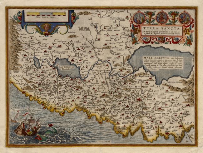
Title:
“Terra Sancta, A Petro Laicstain perlustrata, et ab eius ore et schedis a Christiano Schrot in tabulam redacta”
Map Maker:
Abraham Ortelius
Considered the most "modern" of Ortelius' maps of ... (full text available to subscribers)
| Item Detail |
| |
| |
MapMaker: |
Abraham Ortelius
|
|
| |
| |
Subject: |
Holy Land |
|
| |
Period/Size: |
1584 / 14.5" x 19.7" (36.9 x 50.1 cm)
|
|
| |
Color: |
Colored
|
|
| |
Condition: |
(A) Beautiful impression and fine coloring. Old paper repairs to margins to replace missing corners, map very good. (condition help) |
|
| |
Source: |
Theatrum Orbis Terrarum |
|
| |
References: |
Nebenzahl (HL), pl. 31; Laor 543; Van den Broecke 173. |
|
| |
|
|
| Sales Information |
| |
| |
Price: |
|
|
| |
| |
Offered by: |
Old World Auctions |
|
| |
Catalog: |
Auction No. 104 - Antique Maps, Charts, Atlases & Globes (351) |
|
| |
Lot/Item #: |
536 |
|
| |
| |
Date: |
09/2003
|
|
| |
| |
|
Antique Maps - Valuation and Pricing, Descriptions, Resources |
|
Home |
Information |
Search |
Register |
Contact Us |
Site Map
Americana Exchange, Inc. © 1999 - 2024 Americana Exchange, Inc.. All rights reserved.
OldMaps.com, the OldMaps.com logo and
AMPR are service marks or registered service marks of Americana Exchange, Inc..
|