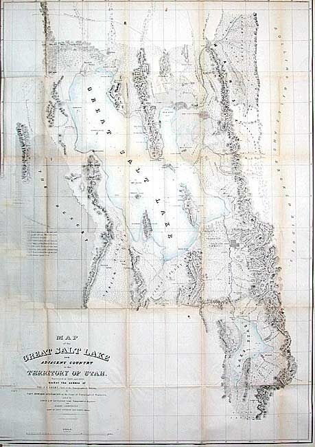
Title:
“Map of the Great Salt Lake and Adjacent Country in the Territory of Utah”
Map Maker:
Howard Stansbury
Stansbury's important exploration of the Great Sal... (full text available to subscribers)
| Item Detail |
| |
| |
MapMaker: |
Howard Stansbury
|
|
| |
| |
Subject: |
Utah |
|
| |
Period/Size: |
1852 / 42.5" x 29.9" (108.0 x 76.0 cm)
|
|
| |
Color: |
Colored
|
|
| |
Condition: |
(B) Original light wash color in lakes. Folding as issued with minor toning at folds. Trimmed into neatline at binding side. Couple of very tiny separations at fold intersections. Overall very good for a map of this size. (condition help) |
|
| |
Source: |
An Expedition to the Valley of the Great Salt Lake of Utahģ |
|
| |
References: |
Wagner-Camp #219:1; Wheat [TMW] #765. |
|
| |
|
|
| Sales Information |
| |
| |
Price: |
|
|
| |
| |
Offered by: |
Old World Auctions |
|
| |
Catalog: |
Auction No. 104 - Antique Maps, Charts, Atlases & Globes (351) |
|
| |
Lot/Item #: |
257 |
|
| |
| |
Date: |
09/2003
|
|
| |
| |
|
Antique Maps - Valuation and Pricing, Descriptions, Resources |
|
Home |
Information |
Search |
Register |
Contact Us |
Site Map
Americana Exchange, Inc. © 1999 - 2024 Americana Exchange, Inc.. All rights reserved.
OldMaps.com, the OldMaps.com logo and
AMPR are service marks or registered service marks of Americana Exchange, Inc..
|