Title:
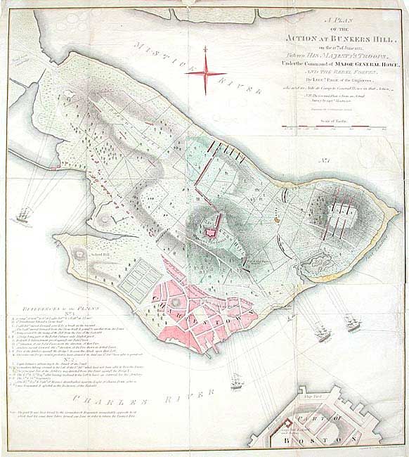
“A Plan of the Action at Bunkers Hill, on the 17th of June 1775 Between His. Majesty's Troops, Under the Command of Major General Howe, and the Rebel Forces”
Map Maker:
William Faden
A slightly reduced size reproduction of this famou... (full text available to subscribers)
| Item Detail |
| |
| |
MapMaker: |
William Faden
|
|
| |
| |
Subject: |
Colonial New England |
|
| |
Period/Size: |
1849 / 18.2" x 16.6" (46.3 x 42.2 cm)
|
|
| |
Color: |
Colored
|
|
| |
Condition: |
(C) Several old repairs on verso with scotch tape that should be replaced. A few small tears along fold lines. (condition help) |
|
| |
Source: |
Frothingham's History |
|
| |
References: |
cf. Nebenzahl (AR) #4. |
|
| |
|
|
| Sales Information |
| |
| |
Price: |
|
|
| |
| |
Offered by: |
Old World Auctions |
|
| |
Catalog: |
Auction No. 104 - Antique Maps, Charts, Atlases & Globes (351) |
|
| |
Lot/Item #: |
131 |
|
| |
| |
Date: |
09/2003
|
|
| |
| |
|
Antique Maps - Valuation and Pricing, Descriptions, Resources |
|
Home |
Information |
Search |
Register |
Contact Us |
Site Map
Americana Exchange, Inc. © 1999 - 2024 Americana Exchange, Inc.. All rights reserved.
OldMaps.com, the OldMaps.com logo and
AMPR are service marks or registered service marks of Americana Exchange, Inc..
|