Rister or Sign In to see pricing information


Title:

The Principal Islands of the East-Indies. Explaining what belongs to England, Spain and Holland &c.

Map Maker:

Herman Moll

The Principal Islands of the East-Indies. Explaining what belongs to England, Spain and Holland &c.

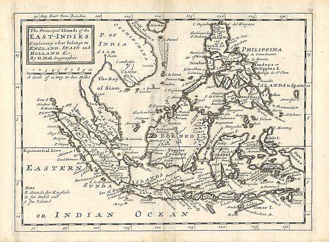
Bold copper engraved chart of the East Indies and ... (full text available to subscribers)
Item Detail
 
  MapMaker:  

Herman Moll


  Subject:  East Indies - Indonesia  
  Period/Size:  1732 / 7.7" x 10.5"  (19.6 x 26.7 cm)  
  Color:  Black & White  
  Condition:  (A) Beautiful, early impression with layout lines still evident. Trace of offsetting, else fine. (condition help)  
  Source:  Atlas Minor...  
  References:   
 
 
Sales Information
 
  Price: 

Please register your email to view records, or sign in with email address to see records


  Offered by:  Old World Auctions  
  Catalog:  Auction No. 105 - Antique Maps, Charts, Atlases & Globes (358)  
  Lot/Item #:  506  
 
  Date:  12/2003  


Antique Maps - Valuation and Pricing, Descriptions, Resources


Home | Information | Search | Register | Contact Us | Site Map

Americana Exchange, Inc. © 1999 - 2024 Americana Exchange, Inc.. All rights reserved. OldMaps.com, the OldMaps.com logo and
AMPR are service marks or registered service marks of Americana Exchange, Inc..