Title:
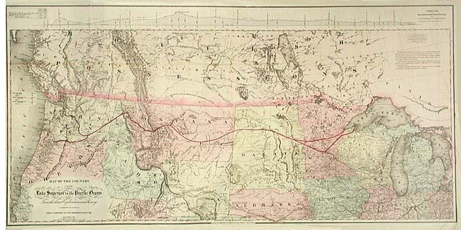
“Map of the Country from Lake Superior to the Pacific Ocean. From the latest Explorations and Surveys to accompany the Report of Edwin F. Johnson Chf. Engr. Northern Pacific R.R.”
Map Maker:
G.W. & C.B Colton [& Co.]
Large and very detailed railroad map covering from... (full text available to subscribers)
| Item Detail |
| |
| |
MapMaker: |
G.W. & C.B Colton [& Co.]
|
|
| |
| |
Subject: |
Western Canada and United States |
|
| |
Period/Size: |
1867 / 21.8" x 45.0" (55.4 x 114.3 cm)
|
|
| |
Color: |
Colored
|
|
| |
Condition: |
(B) Backed with archival tissue. Toned along one fold and a little wrinkling in the thin paper, else very good. (condition help) |
|
| |
Source: |
|
|
| |
References: |
|
|
| |
|
|
| Sales Information |
| |
| |
Price: |
|
|
| |
| |
Offered by: |
Old World Auctions |
|
| |
Catalog: |
Auction No. 105 - Antique Maps, Charts, Atlases & Globes (358) |
|
| |
Lot/Item #: |
130 |
|
| |
| |
Date: |
12/2003
|
|
| |
| |
|
Antique Maps - Valuation and Pricing, Descriptions, Resources |
|
Home |
Information |
Search |
Register |
Contact Us |
Site Map
Americana Exchange, Inc. © 1999 - 2024 Americana Exchange, Inc.. All rights reserved.
OldMaps.com, the OldMaps.com logo and
AMPR are service marks or registered service marks of Americana Exchange, Inc..
|