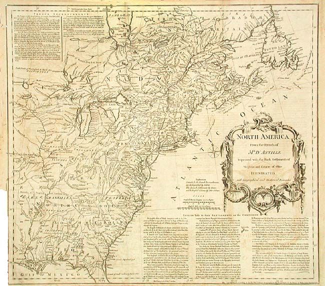
Title:
“North America From the French of Mr. D' Anville Improved with the Back Settlements of Virginia and Course of Ohio Illustrated with Geographical and Historical Remarks”
Map Maker:
Thomas Jefferys
First state of this important map detailing the Br... (full text available to subscribers)
| Item Detail |
| |
| |
MapMaker: |
Thomas Jefferys
|
|
| |
| |
Subject: |
Colonial North America |
|
| |
Period/Size: |
1755 / 18.0" x 20.0" (45.8 x 50.8 cm)
|
|
| |
Color: |
Black & White
|
|
| |
Condition: |
(B) Issued folded, trimmed to neatline at binding side. Short binding tear and one fold separation repaired with archival tape. Light offsetting. (condition help) |
|
| |
Source: |
|
|
| |
References: |
McCorkle #755.2; Stevens & Tree #51; Sellers and Van Ee #29. |
|
| |
|
|
| Sales Information |
| |
| |
Price: |
|
|
| |
| |
Offered by: |
Old World Auctions |
|
| |
Catalog: |
Auction No. 105 - Antique Maps, Charts, Atlases & Globes (358) |
|
| |
Lot/Item #: |
100 |
|
| |
| |
Date: |
12/2003
|
|
| |
| |
|
Antique Maps - Valuation and Pricing, Descriptions, Resources |
|
Home |
Information |
Search |
Register |
Contact Us |
Site Map
Americana Exchange, Inc. © 1999 - 2024 Americana Exchange, Inc.. All rights reserved.
OldMaps.com, the OldMaps.com logo and
AMPR are service marks or registered service marks of Americana Exchange, Inc..
|