Rister or Sign In to see pricing information


Title:

A Physical Planisphere wherein are represented all the known Lands and Seas in the Great Chains of Mountains wch. traverse the Globe from the North Pole…

Map Maker:

Benjamin Cole

A Physical Planisphere wherein are represented all the known Lands and Seas in the Great Chains of Mountains wch. traverse the Globe from the North Pole…

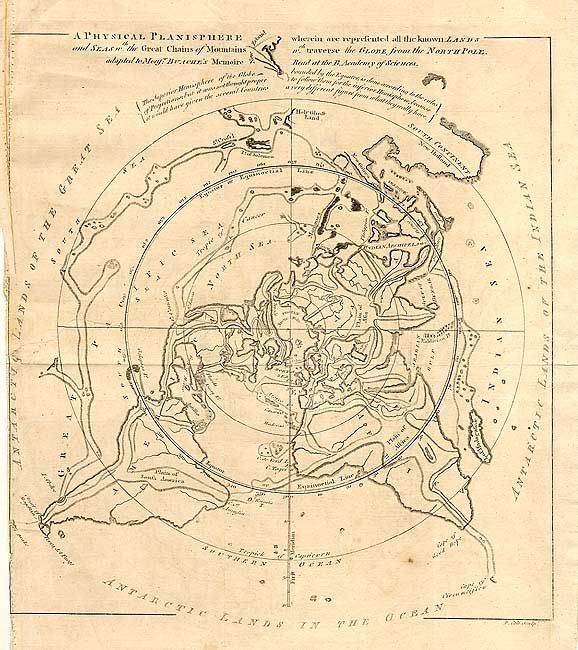
Very unusual map projected from the North Pole to ... (full text available to subscribers)
Item Detail
 
  MapMaker:  

Benjamin Cole


  Subject:  North Pole  
  Period/Size:  1757 / 12.2" x 11.5"  (31.0 x 29.3 cm)  
  Color:  Black & White  
  Condition:  (B) Trimmed to neatline at binding side with 4.5" tear into map closed on verso with archival tape. (condition help)  
  Source:  Gentleman's Magazine  
  References:  Jolly GENT-104.  
 
 
Sales Information
 
  Price: 

Please register your email to view records, or sign in with email address to see records


  Offered by:  Old World Auctions  
  Catalog:  Auction No. 105 - Antique Maps, Charts, Atlases & Globes (358)  
  Lot/Item #:  052  
 
  Date:  12/2003  


Antique Maps - Valuation and Pricing, Descriptions, Resources


Home | Information | Search | Register | Contact Us | Site Map

Americana Exchange, Inc. © 1999 - 2024 Americana Exchange, Inc.. All rights reserved. OldMaps.com, the OldMaps.com logo and
AMPR are service marks or registered service marks of Americana Exchange, Inc..