Title:
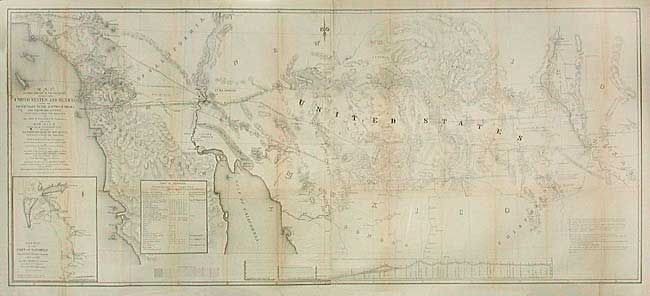
“Map of that Portion of the Boundary between the United States and Mexico, from the Pacific Coast to the Junction of the Gila and Colorado Rivers...and The Rio Gila from Near its Intersection with the Southern Boundary of New Mexico…”
Map Maker:
John Russell Bartlett
Informative map that shows the territory acquired ... (full text available to subscribers)
| Item Detail |
| |
| |
MapMaker: |
John Russell Bartlett
|
|
| |
| |
Subject: |
Southwest United States and Mexico |
|
| |
Period/Size: |
1854-55 / 21.5" x 49.4" (54.7 x 125.5 cm)
|
|
| |
Color: |
Black & White
|
|
| |
Condition: |
(B) Backed with archival tissue. Toned along some folds and closed tear into map at binding trim, else very good. (condition help) |
|
| |
Source: |
Senate Doc. 55, 33rd Congress, 2nd Session |
|
| |
References: |
Wheat [TMW] 821. |
|
| |
|
|
| Sales Information |
| |
| |
Price: |
|
|
| |
| |
Offered by: |
Old World Auctions |
|
| |
Catalog: |
Auction No. 105 - Antique Maps, Charts, Atlases & Globes (358) |
|
| |
Lot/Item #: |
230 |
|
| |
| |
Date: |
12/2003
|
|
| |
| |
|
Antique Maps - Valuation and Pricing, Descriptions, Resources |
|
Home |
Information |
Search |
Register |
Contact Us |
Site Map
Americana Exchange, Inc. © 1999 - 2024 Americana Exchange, Inc.. All rights reserved.
OldMaps.com, the OldMaps.com logo and
AMPR are service marks or registered service marks of Americana Exchange, Inc..
|