Title:
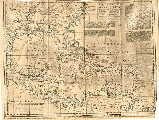
“An Accurate Map of the West Indies, Exhibiting not only all the Islands possess'd by the English, French Spaniards, & Dutch, but also all Towns and Settlements on the Continent of America adjacent thereto”
Map Maker:
Emanuel Bowen
Fascinating map covering the Southern U.S., Centra... (full text available to subscribers)
| Item Detail |
| |
| |
MapMaker: |
Emanuel Bowen
|
|
| |
| |
Subject: |
Caribbean |
|
| |
Period/Size: |
1740 / 11.5" x 15.0" (29.3 x 38.1 cm)
|
|
| |
Color: |
Black & White
|
|
| |
Condition: |
(B) Folding as issued and on fine thick paper with a very sharp impression. Light scattered foxing. (condition help) |
|
| |
Source: |
Gentleman's Magazine |
|
| |
References: |
Jolly GENT-6. |
|
| |
|
|
| Sales Information |
| |
| |
Price: |
|
|
| |
| |
Offered by: |
Old World Auctions |
|
| |
Catalog: |
Auction No. 106 - Antique Maps, Charts, Atlases & Globes (359) |
|
| |
Lot/Item #: |
241 |
|
| |
| |
Date: |
03/2003
|
|
| |
| |
|
Antique Maps - Valuation and Pricing, Descriptions, Resources |
|
Home |
Information |
Search |
Register |
Contact Us |
Site Map
Americana Exchange, Inc. © 1999 - 2024 Americana Exchange, Inc.. All rights reserved.
OldMaps.com, the OldMaps.com logo and
AMPR are service marks or registered service marks of Americana Exchange, Inc..
|