Title:
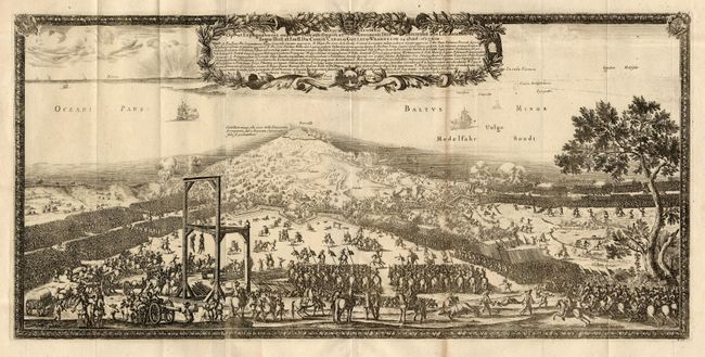
“Repraesentatio Op et Expugnationis nuper exltructi Oppidi et Munimenti Fridericiudde abs Locumtenen te Regio Illust et Exell dn Comiti Carolo Gustavo Wrangelio…”
Map Maker:
Samuel von Pufendorf
Fabulous panoramic view of a battle for the fortre... (full text available to subscribers)
| Item Detail |
| |
| |
MapMaker: |
Samuel von Pufendorf
|
|
| |
| |
Subject: |
Denmark |
|
| |
Period/Size: |
1697 / 10.7" x 22.2" (27.2 x 56.4 cm)
|
|
| |
Color: |
Black & White
|
|
| |
Condition: |
(B) Toned along one fold. (condition help) |
|
| |
Source: |
Histoire du regne de Charles Gustave, roy de Suede |
|
| |
References: |
|
|
| |
|
|
| Sales Information |
| |
| |
Price: |
|
|
| |
| |
Offered by: |
Old World Auctions |
|
| |
Catalog: |
Auction No. 106 - Antique Maps, Charts, Atlases & Globes (359) |
|
| |
Lot/Item #: |
336 |
|
| |
| |
Date: |
03/2003
|
|
| |
| |
|
Antique Maps - Valuation and Pricing, Descriptions, Resources |
|
Home |
Information |
Search |
Register |
Contact Us |
Site Map
Americana Exchange, Inc. © 1999 - 2024 Americana Exchange, Inc.. All rights reserved.
OldMaps.com, the OldMaps.com logo and
AMPR are service marks or registered service marks of Americana Exchange, Inc..
|