Title:
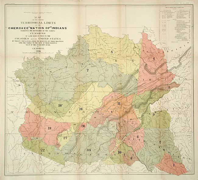
“Map of the Former Territorial Limits of the Cherokee "Nation of" Indians [together with] Map Showing the Territory Originally Assigned to the Cherokee "Nation of" Indians West of the Mississippi…”
Map Maker:
Charles C. Royce
Pair of large maps depicting, in a colored and num... (full text available to subscribers)
| Item Detail |
| |
| |
MapMaker: |
Charles C. Royce
|
|
| |
| |
Subject: |
United States - Central & Oklahoma |
|
| |
Period/Size: |
1884 / unknown
|
|
| |
Color: |
Colored
|
|
| |
Condition: |
(A) Both issued folding, now backed with archival tissue. Very light fold toning of latter, still very good. (condition help) |
|
| |
Source: |
5th Annual Report Bureau of Ethnology |
|
| |
References: |
|
|
| |
|
|
| Sales Information |
| |
| |
Price: |
|
|
| |
| |
Offered by: |
Old World Auctions |
|
| |
Catalog: |
Auction No. 107 - Antique Maps, Charts, Atlases & Globes (361) |
|
| |
Lot/Item #: |
144 |
|
| |
| |
Date: |
06/2004
|
|
| |
| |
|
Antique Maps - Valuation and Pricing, Descriptions, Resources |
|
Home |
Information |
Search |
Register |
Contact Us |
Site Map
Americana Exchange, Inc. © 1999 - 2024 Americana Exchange, Inc.. All rights reserved.
OldMaps.com, the OldMaps.com logo and
AMPR are service marks or registered service marks of Americana Exchange, Inc..
|