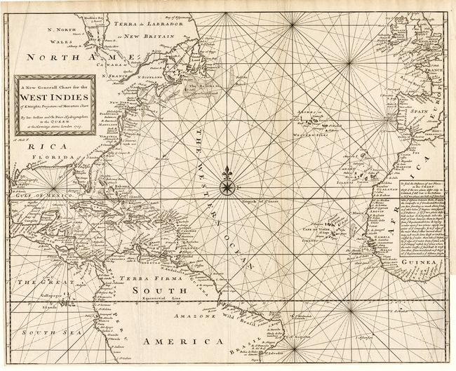
Title:
“A New Generall Chart for the West Indies on E. Wrights Projection”
Map Maker:
Seller & Price
A fine sea chart covering most of the Atlantic Oce... (full text available to subscribers)
| Item Detail |
| |
| |
MapMaker: |
Seller & Price
|
|
| |
| |
Subject: |
Atlantic and West Indies |
|
| |
Period/Size: |
1703 / 17.8" x 22.7" (45.3 x 57.7 cm)
|
|
| |
Color: |
Black & White
|
|
| |
Condition: |
(A) Sharp impression. Issued folding and now pressed. Close margins as issued with a tiny repaired binding tear just touching neatline. (condition help) |
|
| |
Source: |
|
|
| |
References: |
|
|
| |
|
|
| Sales Information |
| |
| |
Price: |
|
|
| |
| |
Offered by: |
Old World Auctions |
|
| |
Catalog: |
Auction No. 107 - Antique Maps, Charts, Atlases & Globes (361) |
|
| |
Lot/Item #: |
273 |
|
| |
| |
Date: |
06/2004
|
|
| |
| |
|
Antique Maps - Valuation and Pricing, Descriptions, Resources |
|
Home |
Information |
Search |
Register |
Contact Us |
Site Map
Americana Exchange, Inc. © 1999 - 2024 Americana Exchange, Inc.. All rights reserved.
OldMaps.com, the OldMaps.com logo and
AMPR are service marks or registered service marks of Americana Exchange, Inc..
|