Rister or Sign In to see pricing information


Title:

A Map of the Icy Sea in which the several Communications with the Land Waters and other new Discoveries are exhibited

Map Maker:

John Gibson

A Map of the Icy Sea in which the several Communications with the Land Waters and other new Discoveries are exhibited

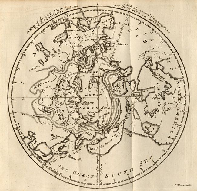
Based on the work of Jean Palairet, this is a very... (full text available to subscribers)
Item Detail
 
  MapMaker:  

John Gibson


  Subject:  North Pole  
  Period/Size:  1760 / 7.8" x 7.8"  (19.9 x 19.9 cm)  
  Color:  Black & White  
  Condition:  (A+) Dark, early impression on thick hand-laid paper. Trace of offsetting, still fine. (condition help)  
  Source:  Gentleman's Magazine  
  References:  Jolly GENT-141.  
 
 
Sales Information
 
  Price: 

Please register your email to view records, or sign in with email address to see records


  Offered by:  Old World Auctions  
  Catalog:  Auction No. 108 - Antique Maps, Charts, Atlases & Globes (362)  
  Lot/Item #:  051  
 
  Date:  09/2004  


Antique Maps - Valuation and Pricing, Descriptions, Resources


Home | Information | Search | Register | Contact Us | Site Map

Americana Exchange, Inc. © 1999 - 2024 Americana Exchange, Inc.. All rights reserved. OldMaps.com, the OldMaps.com logo and
AMPR are service marks or registered service marks of Americana Exchange, Inc..