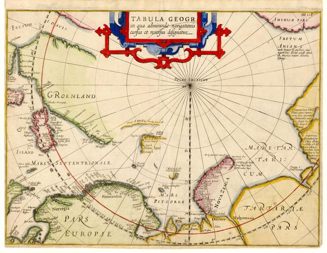
Title:
“Tabula Geogr. in qua admiranda navigationis cursus et recursus designatur”
Map Maker:
Johannes Isaksen Pontanus
Scarce map of the North Pole and Arctic regions sh... (full text available to subscribers)
| Item Detail |
| |
| |
MapMaker: |
Johannes Isaksen Pontanus
|
|
| |
| |
Subject: |
North Pole |
|
| |
Period/Size: |
1611 / 10.5" x 14.0" (26.7 x 35.6 cm)
|
|
| |
Color: |
Colored
|
|
| |
Condition: |
(B) Tight margins on three sides as issued. Bit of minor soil. (condition help) |
|
| |
Source: |
Rerum et Urbis Amstelodamensium Historia |
|
| |
References: |
|
|
| |
|
|
| Sales Information |
| |
| |
Price: |
|
|
| |
| |
Offered by: |
Old World Auctions |
|
| |
Catalog: |
Auction No. 108 - Antique Maps, Charts, Atlases & Globes (362) |
|
| |
Lot/Item #: |
045 |
|
| |
| |
Date: |
09/2004
|
|
| |
| |
|
Antique Maps - Valuation and Pricing, Descriptions, Resources |
|
Home |
Information |
Search |
Register |
Contact Us |
Site Map
Americana Exchange, Inc. © 1999 - 2024 Americana Exchange, Inc.. All rights reserved.
OldMaps.com, the OldMaps.com logo and
AMPR are service marks or registered service marks of Americana Exchange, Inc..
|