Title:
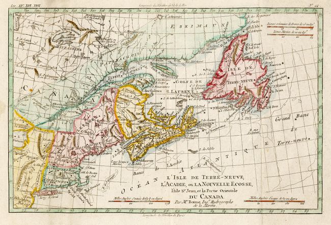
“L'Isle de Terre-Neuve, l'Acadie, on la Nouvelle Ecosse, I'Isle St. Jean, et la partie Orientale du Canada”
Map Maker:
Rigobert Bonne
Copper engraved map of the Maritimes as far west a... (full text available to subscribers)
| Item Detail |
| |
| |
MapMaker: |
Rigobert Bonne
|
|
| |
| |
Subject: |
Canada & New England |
|
| |
Period/Size: |
1783 / 8.2" x 12.5" (20.9 x 31.8 cm)
|
|
| |
Color: |
Colored
|
|
| |
Condition: |
(B) Bit of minor surface soil. (condition help) |
|
| |
Source: |
Raynal's Atlas de toutes les parties connues du globe terrestre |
|
| |
References: |
Kershaw #720; McCorkle #782.3; Sellers and van Ee #172. |
|
| |
|
|
| Sales Information |
| |
| |
Price: |
|
|
| |
| |
Offered by: |
Old World Auctions |
|
| |
Catalog: |
Auction No. 108 - Antique Maps, Charts, Atlases & Globes (362) |
|
| |
Lot/Item #: |
133 |
|
| |
| |
Date: |
09/2004
|
|
| |
| |
|
Antique Maps - Valuation and Pricing, Descriptions, Resources |
|
Home |
Information |
Search |
Register |
Contact Us |
Site Map
Americana Exchange, Inc. © 1999 - 2024 Americana Exchange, Inc.. All rights reserved.
OldMaps.com, the OldMaps.com logo and
AMPR are service marks or registered service marks of Americana Exchange, Inc..
|