Title:
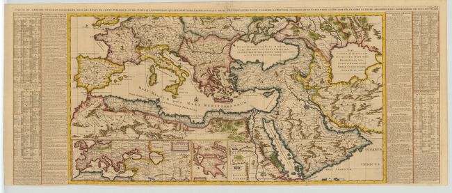
“Carte de l' Empire Othoman Consideree dans les Etats de Cette Puissance, et des Etats qui l' Avoisinent ou qui luy sont Tributaires, Ainsi que Deux Petites Cartes pour Conduire, a l' Histoire Universel et en Particulier a l'Histoire d' Alexandre le Grand”
Map Maker:
Henry Abraham Chatelain
Grand map of the Mediterranean and Near East exten... (full text available to subscribers)
| Item Detail |
| |
| |
MapMaker: |
Henry Abraham Chatelain
|
|
| |
| |
Subject: |
Mediterranean & Near East |
|
| |
Period/Size: |
1714 / 19.0" x 35.5" (48.3 x 90.2 cm)
|
|
| |
Color: |
Colored
|
|
| |
Condition: |
(A) Lovely coloring. Tissue reinforced joint and a couple of minor fold separations repaired with tissue. (condition help) |
|
| |
Source: |
Atlas Historique |
|
| |
References: |
|
|
| |
|
|
| Sales Information |
| |
| |
Price: |
|
|
| |
| |
Offered by: |
Old World Auctions |
|
| |
Catalog: |
Auction No. 108 - Antique Maps, Charts, Atlases & Globes (362) |
|
| |
Lot/Item #: |
505 |
|
| |
| |
Date: |
09/2004
|
|
| |
| |
|
Antique Maps - Valuation and Pricing, Descriptions, Resources |
|
Home |
Information |
Search |
Register |
Contact Us |
Site Map
Americana Exchange, Inc. © 1999 - 2024 Americana Exchange, Inc.. All rights reserved.
OldMaps.com, the OldMaps.com logo and
AMPR are service marks or registered service marks of Americana Exchange, Inc..
|