Title:
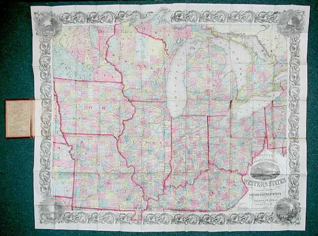
“Colton's Railroad & Township Map of the Western States compiled from the United States Surveys”
Map Maker:
Joseph Hutchins Colton
A large and beautifully detailed map of the midwes... (full text available to subscribers)
| Item Detail |
| |
| |
MapMaker: |
Joseph Hutchins Colton
|
|
| |
| |
Subject: |
United States - Central |
|
| |
Period/Size: |
1855 / 33.5" x 41.0" (85.1 x 104.2 cm)
|
|
| |
Color: |
Colored
|
|
| |
Condition: |
(A) Fine impression and coloring with a few tiny fold intersection splits and mis-folded, else remarkable condition. Cover a little rubbed with owner's signatures inside front cover. (condition help) |
|
| |
Source: |
|
|
| |
References: |
Rumsey #4985. |
|
| |
|
|
| Sales Information |
| |
| |
Price: |
|
|
| |
| |
Offered by: |
Old World Auctions |
|
| |
Catalog: |
Auction No. 108 - Antique Maps, Charts, Atlases & Globes (362) |
|
| |
Lot/Item #: |
151 |
|
| |
| |
Date: |
09/2004
|
|
| |
| |
|
Antique Maps - Valuation and Pricing, Descriptions, Resources |
|
Home |
Information |
Search |
Register |
Contact Us |
Site Map
Americana Exchange, Inc. © 1999 - 2024 Americana Exchange, Inc.. All rights reserved.
OldMaps.com, the OldMaps.com logo and
AMPR are service marks or registered service marks of Americana Exchange, Inc..
|