Title:
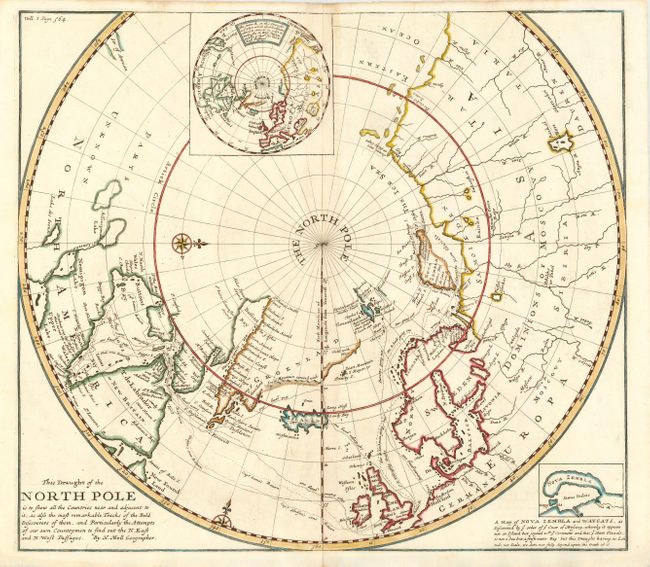
“This Draught of the North Pole is to Shew all the Countries near and adjacent to it, as also the most remarkable Tracks of the Bold Discoverers of them, and Particularly the Attempts of our own Countrymen to find out the N. East and N. West Passages”
Map Maker:
Herman Moll
Boldly engraved chart of the polar region to 50° N... (full text available to subscribers)
| Item Detail |
| |
| |
MapMaker: |
Herman Moll
|
|
| |
| |
Subject: |
North Pole |
|
| |
Period/Size: |
1705 / 14.7" x 16.7" (37.4 x 42.5 cm)
|
|
| |
Color: |
Colored
|
|
| |
Condition: |
(A+) Dark impression on hand-laid paper, with fine modern coloring. Close margins, as issued. (condition help) |
|
| |
Source: |
|
|
| |
References: |
|
|
| |
|
|
| Sales Information |
| |
| |
Price: |
|
|
| |
| |
Offered by: |
Old World Auctions |
|
| |
Catalog: |
Auction No. 108 - Antique Maps, Charts, Atlases & Globes (362) |
|
| |
Lot/Item #: |
050 |
|
| |
| |
Date: |
09/2004
|
|
| |
| |
|
Antique Maps - Valuation and Pricing, Descriptions, Resources |
|
Home |
Information |
Search |
Register |
Contact Us |
Site Map
Americana Exchange, Inc. © 1999 - 2024 Americana Exchange, Inc.. All rights reserved.
OldMaps.com, the OldMaps.com logo and
AMPR are service marks or registered service marks of Americana Exchange, Inc..
|